
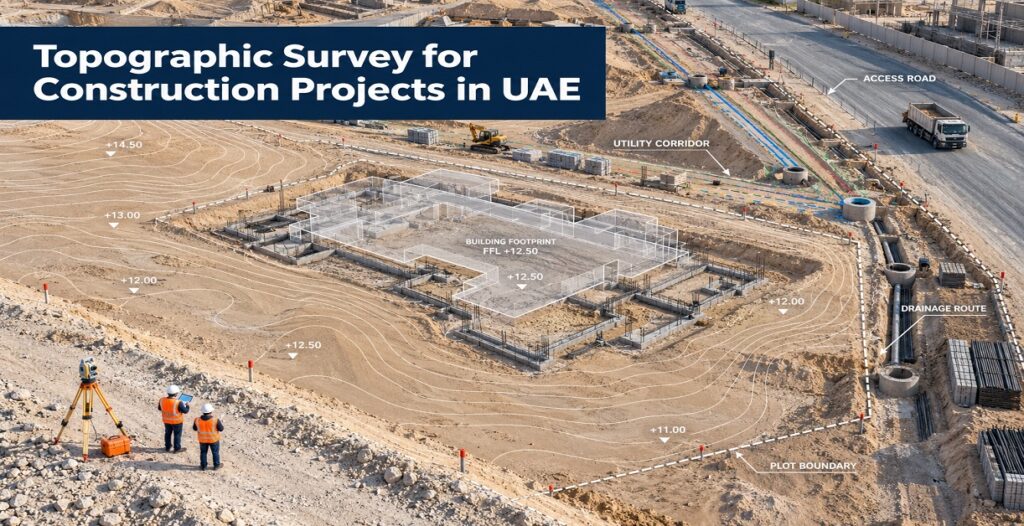
A design may look correct on a screen but fail when it meets the actual ground. An unexpected slope can change foundation levels. An unrecorded wall may affect access. Incorrect drainage levels can cause water to collect around a building. Even a small difference between the drawing and the site can lead to redesign, delays and extra costs.
A detailed topographic survey for construction projects in UAE provides the measured site information needed before design and construction begin. It shows the shape of the land, existing structures, visible utilities, roads, boundaries and levels in one coordinated survey drawing.
The value of this survey is not limited to producing a map. Its real purpose is to reduce uncertainty before expensive work starts on site.
Why Site Assumptions Create Expensive Problems
Architects and engineers need accurate existing-site information to prepare their designs. If the survey data is incomplete or outdated, important decisions may be based on assumptions.
These problems commonly appear later as:
- Building levels that do not match the surrounding road
- Incorrect excavation or filling quantities
- Drainage routes with insufficient slope
- Designs that clash with existing structures
- Access roads that require unexpected changes
- Retaining walls added after construction begins
- Delays while drawings are revised and approved again
Finding these issues during the design stage is far cheaper than discovering them after mobilisation, excavation or concrete work.
1. Accurate Ground Levels Improve Building Design
A topographic survey records spot levels and contours across the site. These measurements show how the land rises, falls and connects with nearby roads, plots and structures.
Design teams use this information to establish:
- Finished floor levels
- Foundation depths
- Ramp and access gradients
- Road connection levels
- Retaining-wall requirements
- Cut-and-fill areas
- Surface-water flow
Without reliable levels, the proposed design may sit too high or too low compared with the surrounding area. Correcting that issue later can affect foundations, entrances, utilities and external landscaping.
For projects moving from design into site execution, accurate survey control must continue through the building construction survey stage so that approved coordinates and levels are transferred correctly to the ground.
2. Topographic Data Supports Better Drainage Planning
Drainage depends on elevation. Water follows the ground profile, so small level differences can decide whether runoff reaches the correct outlet or collects in an unwanted area.
A topographic survey helps engineers understand:
- Existing high and low points
- Road and kerb levels
- Manhole positions
- Drainage channels
- Natural flow directions
- Connections with neighbouring land
- Areas that may require grading
This information is especially important on flat sites where a minor level error can affect the entire drainage design.
Surveyors should record all relevant drainage features clearly. Designers can then plan slopes and outlet connections using measured information instead of visual estimates.
3. Reliable Surveys Reduce Earthwork Quantity Errors
Excavation, filling and land grading can account for a large part of a project’s early cost. Incorrect existing-ground levels produce incorrect quantities, which can affect budgets, tender comparisons and material planning.
A topographic survey creates the base surface used to calculate:
- Excavation volumes
- Filling requirements
- Site grading quantities
- Formation levels
- Stockpile volumes
- Surplus or required material
The existing survey should be completed before earthwork starts. Later measurements can then be compared with the original surface through professional measurement survey services.
Using the same coordinate and level reference throughout the project also makes quantity comparisons easier to check and defend.
4. Existing Features Can Be Included Before Design Starts
Construction sites are rarely empty. Even an undeveloped plot may contain boundary walls, access tracks, utility markers, poles, trees, drainage structures or neighbouring features that affect the proposed work.
A detailed topographic survey can record:
- Existing buildings
- Boundary walls and fences
- Roads and footpaths
- Kerbs and parking areas
- Manholes and visible services
- Streetlights and utility poles
- Trees and landscape features
- Nearby structures that affect access
When these features appear correctly in the base drawing, architects and engineers can work around them from the beginning.
This reduces the risk of site teams discovering a physical obstruction after drawings have already been issued.
5. Control Points Keep Every Measurement Connected
Survey data is only useful when every measurement follows the same coordinate and level reference. That reference is created through fixed survey control.
Professionally established control points allow survey teams, contractors and consultants to work within one consistent system. They support the original topographic survey as well as later setting-out, level checks and as-built measurements.
Poor or disturbed control can create differences between separate surveys. These differences may appear as shifted coordinates, incorrect levels or misaligned construction elements.
Control points should therefore be:
- Located in stable positions
- Clearly marked and recorded
- Checked before important survey work
- Protected from construction activity
- Connected to the required project coordinate system
6. Infrastructure Projects Need Wider Survey Coverage
Road, pipeline, drainage and utility projects usually extend beyond a single building plot. Their survey requirements may include long corridors, road crossings, tie-in locations and existing networks.
For these projects, topographic data may be required for:
- Route alignment
- Road profiles and cross-sections
- Drainage paths
- Utility corridors
- Existing junctions
- Tie-in levels
- Access and working areas
Specialist infrastructure construction surveys keep design and setting-out information connected across the full project area.
The survey scope should define how far beyond the proposed route the field team must measure. A narrow survey strip may miss nearby features that later affect the design.
What Should Be Checked Before Using Survey Data?
Before issuing topographic data to the design team, check that the survey package clearly identifies:
- Coordinate system
- Vertical datum or benchmark
- Survey date
- Drawing scale
- Contour interval
- Spot levels
- Control-point information
- Included site features
- Survey limits
- CAD layer structure
The survey date matters because construction sites change quickly. An old drawing may no longer show current ground levels, temporary works or newly constructed features.
If major site activity has taken place since the survey, confirm whether an updated survey is required.
When Should a Topographic Survey Be Updated?
A new or updated topographic survey may be needed when:
- Excavation or filling has changed the ground
- Existing structures have been demolished
- New roads or utilities have been installed
- The project boundary or scope has changed
- The original survey is several months old
- Designers need more detail in a specific area
- Survey control has been disturbed
Updating only the changed area may be enough in some cases. However, the new information must be checked against the original control system before both datasets are combined.
Maintaining Survey Support During Construction
The first topographic survey provides the design base, but construction creates ongoing measurement needs. These may include setting-out, level checks, quantity surveys, progress measurements and as-built records.
Projects with frequent survey requirements may benefit from a dedicated survey crew hire service. Daily, monthly or yearly deployment gives the site team faster access to measurements and keeps survey records consistent throughout the project.
Using one survey partner across different stages can also reduce problems caused by changing coordinate systems, file formats or field methods.
Frequently Asked Questions
Can a topographic survey prevent construction delays?
It can reduce delays caused by incorrect site levels, missing features and design conflicts. However, the survey must be completed before the design is finalised.
Is a topographic survey needed for an empty plot?
Yes. An empty plot still has levels, slopes, boundaries, access points and surrounding features that affect the proposed design.
How recent should the survey be?
It should reflect the current site condition. If excavation, filling, demolition or construction has occurred, the survey may need to be updated.
Can topographic data be used for earthwork calculations?
Yes. The measured existing-ground surface can be compared with proposed or completed levels to calculate excavation and filling quantities.
What happens if survey control is disturbed?
The control should be checked or re-established before further survey work. Continuing from an unreliable point can affect all later coordinates and levels.
Do infrastructure projects need a different survey approach?
They often require wider coverage, profiles, cross-sections and measurements along long routes. The scope must match the full design corridor.
Final Thoughts
A topographic survey is one of the earliest tools for controlling construction risk. It gives designers real site levels, helps engineers plan drainage and earthwork, and allows existing features to be included before they create problems.
The best time to find a level conflict, access restriction or drainage issue is before construction begins.
Arabian Survey Engineering LLC provides land, building, infrastructure and measurement surveys across the UAE. The team can support projects from the first site survey through setting-out, quantity measurement and final checks.
📞 Call: +971-55-3605092
💬 WhatsApp: Message our survey team
📧 Email: info@arabianse.com